Phase I
In Phase I of the LTARN, research is conducted across a relatively small, uniform parcel of land at each site. The goal is to understand processes at a large scale, i.e. system-to-system, site-to-site.
A series of six cropping system models, including both annual to perennial crop sequences, are established at the three network nodes in a large-plot replicated design. Crop system models range from simple two-crop rotations to more complex perennial-based cropping systems.
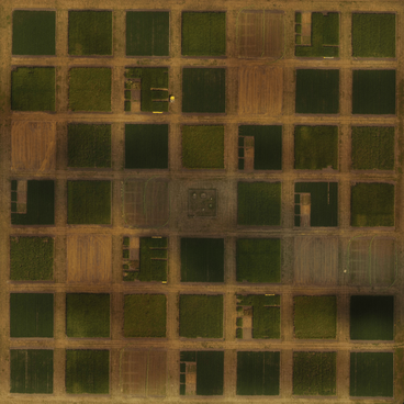
At each site, crops are grown in four main plots, each 24 m x 24 m with eight 6m x 6m sub-plots assigned to specific experiments within each main plot.
Cropping Models
2-Crop Rotation
| Corn/Soybean Rotation | 2 phases x 4 reps = 8 plots |
3-Crop Rotation
| Corn/Soybean/Wheat Rotation | 3 phases x 4 reps = 12 plots |
Annual/Perennial
| Corn/Corn/Alfalfa/Alfalfa/Alfalfa | 3 phases x 4 reps = 12 plots |
Continuous Living Cover
| Silage Corn followed by Brassica/Soybean | 1 phase x 4 reps = 4 plots |
Cover Crops
| Corn/Soybean with Cover Crops | 2 phases x 4 reps = 8 plots |
Perennial Living Cover
| Grass-based Polyculture | 1 phase x 4 reps = 4 plots |
Phase II
In phase II, the goal is to understand processes at a smaller scale, i.e. at the field scale, where variability in terrain and other landscape characteristics become an important factor. In this phase, we will identify representative fields at each site that are typical of local soil and terrain features in the area. This allows us to improve scalability and extrapolation based on an understanding of processes affected by water, incoming solar radiation, soil movement, etc. at the macro- and field-scales. In 2015, these landscape plots were implemented at SROC (Waseca) and SWROC (Lamberton).